Continental Virtual Airlines Cleveland Hub Continental Virtual Airlines Cleveland Huba subsidiary of Northwest Virtual Airlines et al |
||
|
NAVIGATE
|
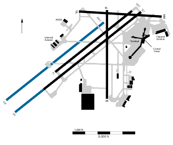
Cleveland - Hopkins International Airport Located 9 MI Southwest of Downtown Lat/Long: N41-24-39.219 / W081-50-57.828 Elevation - 790 ft. Radio Frequencies UNICOM: 122.95
VOR STATIONS IN VICINITY OF AIRPORT DJB - Dryer VORTAC - 14.4 MI - 113.6 LNN - Lost Nation VOR/DME - 26.4 MI - 110.20 CXR - Chardon VOR/DME - 31.5 MI - 112.70 ACO - Akron VOR/DME - 34.4 MI - 114.40 SKY - Sandusky VOR/DME - 36.3 MI - 109.20 RUNWAYS
Courtesy of the FAA
B1900 Photo courtesy of Joe Daniel Flight from Chicago O'Hare landing at Cleveland in an Express Beechcraft 1900D, one of the many express flights originating from Cleveland. All Cleveland Runways are 150 feet wide RUNWAY 23L - ILS Localizer 109.9 - 8999 ft. RUNWAY 5R - ILS Localizer 111.9 - 8999 ft. RUNWAY 23R - 7096 ft. RUNWAY 5L - 7096 ft. RUNWAY 36 / 18 - 6410 ft. RUNWAY 10 / 28 - ILS Localizer ( 28 ) 110.7 - 6015 ft.
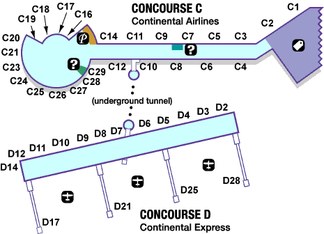
C TERMINAL MAP and D TERMINAL MAP Northwest Virtual Airlines et al is a registered name
|